It is important for all riders to research and plan for their visit to the Forrest MTB Trails. The information below will assist you to have a safe trip and to be prepared for all situations and events.
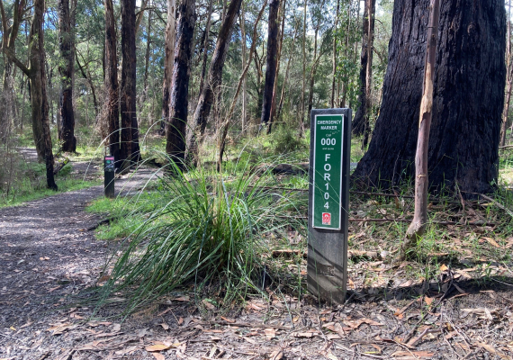
Emergency markers are spaced at regular intervals and can be found on walking tracks and bike paths in the Forrest Mountain Bike Network. Emergency markers are used to identify and verify the location of a triple zero (000) emergency phone call.
Emergency markers have three letters, three numbers and have a green background and white text.
In the event of an emergency phone triple zero (000) and quote the emergency marker followed by the marker reference number
.

There is poor mobile phone reception in the area and you may not be within your network range on some of the Mountain Bike Trails. To be connected to Police, Ambulance or CFA on any network, key in 112, then press the YES key.
Due to the limited mobile reception, the best source of emergency warnings and advice is through the following radio stations:
• 774 AM ABC Melbourne
• 1134 AM 3CS Colac
• 95.9 FM Mixx Apollo Bay
• 106.3 FM Mixx Colac
If reception is available, the following sources of emergency information are available:
Vic Emergency Hotline 1800 226 226
Vic Emergency App
The Forrest MTB trails are in the South West Fire Danger District. While you are here, please continue to monitor the fire danger forecast for the duration of your stay.
It is your responsibility to stay informed about Fire Danger Rating during your visit. Stay informed about the fire danger forecast by downloading the Vic Emergency App. You can also check online at www.cfa.vic.gov.au or call the Vic Emergency Hotline on 1800 226 226.
CATASTROPHIC FIRE DANGER RATING DAYS
On Catastrophic Fire Danger Rating Days, parks and forests are not safe places to be and they will be closed to the public.
For your own safety, do not enter parks or forests and if you are already there you should leave the night before or early in the morning.
You may not receive a personal warning or see signage that the park or forest is closed.
EXTREME FIRE DANGER RATING DAYS
On days of Extreme Fire Danger Rating you should reconsider plans to visit parks and forests, and if you are already within a park or forest the safest option is to leave early in the day.
EVACUATION INFORMATION
Evacuation of the site will be required if:
• An emergency incident is likely to impact the site within 24 hours, or
• An Extreme or Catastrophic day has been declared with insufficient lead time to safely close the site.
In the event that you need to evacuate:
• Your safest option is to leave as soon as possible and travel to the Bushfire Place of Last Resort at Forrest)
• Police and FFMVic staff may not be able to attend the site to support evacuation

Great Ocean Road Regional Tourism acknowledges the Traditional Custodians of the Great Ocean Road region the Wadawurrung, Eastern Maar & Gunditjmara. We pay our respects to their Elders, past, present and emerging. We recognise and respect their unique cultural heritage and the connection to their traditional lands. We commit to building genuine and lasting partnerships that recognise, embrace and support the spirit of reconciliation, working towards self-determination, equity of outcomes and an equal voice for Australia’s first people.